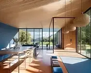
AI Landscape Design Generator
Transform your outdoor space in seconds. With ArchiVinci’s AI Landscape Design tool, you can instantly generate realistic gardens, backyards, and public outdoor layouts. Explore modern, natural, or minimalist concepts and visualize your dream landscape with ease.
Select module*
Seed: 15315451353516613
To generate similar images, use this seed number.

Number of variations
Number of variations
Seed: 15315451353516613
To generate similar images, use this seed number.
Add paragraph text. Click “Edit Text” to customize this theme across your site. You can update and reuse text themes.
AI Landscape Design
• Upload an image of a landscape/garden.
• Define the features of its new look (e.g., 'Add grass field and modern fences. Remove stone pathway').

Open to download
IN PROGRESS...
Have a coffee break while we are proccessing your video
or you can continue generating renders
You'll find this video in your DASHBOARD when it's ready
(about 10 mins)


.jpg)


Input image*

Prompt (Optional)
Number of images*
Error


Long prompts may lead to unexpected results. Keep it short for best results. Here is some tips about prompts: Learn more
Add items
Before & After: Landscape and Garden Transformations
Before ➝ After: Cozy Patio Makeover

Add stone patio with circular borders, lounge seating and outdoor fireplace with TV, dining table set, flower beds with shrubs and small trees, wooden fence and garden lights, lawn with stepping stones, barbecue grill.
Before ➝ After: Elegant Garden Transformation

Add manicured lawn, add colorful flower beds, add shaped shrubs, add round topiary trees, add flowering bushes, add small evergreens, add stone mulch borders, add front porch steps with planters, a pergola in the middle, walking stones.
Before ➝ After: Family-Friendly Backyard Upgrade

Add pergola lounge, add stone patio, add dining set, add kids play area, add stepping stone path, add colorful flower beds, add shrubs and small trees, add fresh lawn, add warm garden lights, add decorative planters.
What Is AI Landscape Design?
AI landscape design applies artificial intelligence to plan, visualize, and iterate outdoor spaces of any scale using your inputs (photos, site data, sketches, or text prompts). It converts ideas into credible concept images, layout alternatives, and editable renderings that you can refine step by step.
What Is AI Landscape Design Generator?
An AI landscape design generator is software that analyzes your inputs and automatically produces multiple landscape concepts. It focuses on rapid variation and side-by-side comparison, then exports results you can edit or iterate further. It organizes planting, hardscape, lighting, and site elements with realistic proportions and materials. The practical goal is to move from rough ideas to convincing visuals quickly while maintaining control of design intent. Outputs include 3D landscape rendering for option review and site plan rendering for coordination, which helps bridge design conversations between disciplines.
How Does an AI Landscape Generator Work?
1) Upload a site photo or scaled plan
Upload a clear site photo or a scaled plan in JPG or PNG up to 5 MB. Frame the whole area, include a known dimension for scale, keep the image sharp and undistorted. Including site context and a simple topography model improves how paths and terraces read in early studies.
2) Enter a clear prompt
Describe goals in plain language. Include size, climate, sun exposure, slope or drainage notes, maintenance level, required functions such as seating or dining or play or fire, preferred style and materials, fixed items to keep, and no-go zones. If you plan a masterplan visualization later, note districts, program areas, and approximate capacities to keep options comparable.
3) Select number of images to generate
Choose how many concepts to generate (1–4). Start with 2 or 3 to explore variety, then switch to 1 for focused refinements.
The Role of AI in Landscape Architecture and Design
Artificial intelligence augments the landscape architect rather than replacing them. It speeds up early site reading by parsing photos and plans to identify edges, access points, circulation, sun and shade patterns, slopes, and likely water paths. It also surfaces practical constraints such as setbacks and protected trees. From a single brief it can generate multiple concept options, compare adjacencies and privacy, test planting density and material palettes, and produce quick before and after visuals, simple diagrams, rough area takeoffs, and lightweight phasing scenarios that make trade-offs easier to discuss. Where needed, ArchiVinci supports lighting simulation, daylight analysis, and shadow study at study level to inform early comfort and usability discussions.
What remains distinctly human is judgment and accountability. Professionals interpret community context, balance ecology with culture, coordinate with engineers and contractors, ensure codes and accessibility are met, and design grading and drainage that actually work. They select region appropriate species, plan for soils, stormwater, habitat, and long-term maintenance, and take responsibility for health, safety, and environmental impact. In practice the best results come when AI is used as a fast concept partner while final decisions are validated on site and through professional review.
What an AI Landscape Design Tool Delivers?
Input Flexibility
Start from site photos, hand sketches, CAD plans, or 3D massing. The tool preserves geometry and scale so edits stay tied to real site constraints. It reads the site plan, facade relationships, and approach axes accurately. Typical inputs cover hardscape and softscape layers, a draft planting palette, and circulation notes for reliable landscape design rendering.
Prompt Controls
Define plant palette, surface materials, seating and dining elements, lighting, season, and time of day. Add climate, maintenance level, irrigation limits, privacy needs, and budget to keep outputs aligned with the brief and a consistent material language.
Terrain Awareness
Understand slope, grade breaks, terraces, and retaining conditions. Get first-pass cues on stormwater direction and permeable surface ratios. Place planting masses along contour while keeping circulation and viewpoints coherent in plan and section. Early topography rendering helps verify steps, ramps, and switchbacks against accessibility goals.
Mask and Inpaint Edits
Protect must-keep elements and edit only targeted areas. Swap materials, rework edging and paths, or adjust planting density without redrawing the entire scene. Existing trees, doors, and utilities remain safeguarded.
Variation Generation
Generate multiple alternatives in a single session and compare them side by side. Evaluate adjacencies, circulation spine, shade and light balance, and privacy scenarios to speed decisions and clarify design intent. For consistent reading, keep focal length and aerial view settings stable across variants.
Scale and Dimension
Export scaled 2D plans with spot levels, dimensions, legend, and layered hardscape and softscape. Files are ready for CAD or BIM handoff, enabling a smooth transition to detailed design and quantity takeoff. Exports can include a vegetation layer for planting counts and a circulation / pathways layer to support coordination.
High-Quality Outputs
Produce photorealistic renders, legible plan graphics, and clear diagrams. Include day and night views, seasonal variants, and before and after comparisons to strengthen communication with clients, committees, and the public. Rendering supports photorealistic rendering techniques like ray tracing, global illumination, and ambient occlusion where hardware allows. Materials benefit from material mapping such as texture mapping, bump map, and displacement for credible detail in exterior rendering. When needed, you can export render passes including diffuse, specular, vegetation pass, and entourage pass for post-production.
Key Benefits of Using AI for Landscape Design
Speed, Accuracy, and Creativity
Teams move from brief to concept images in minutes. Scale, perspective, and lighting stay coherent across iterations. A few controlled variations reveal stronger ideas while the brief remains intact. This accelerates client presentation render workflows and supports experiential rendering studies without heavy manual setup.
Cost and Time Savings
Automated iterations reduce manual drafting and slide building. Clear visuals early in the process improve alignment and cut late rework in an AI-assisted workflow. Early pre-construction visualization reduces uncertainty before procurement.
Clearer Client Alignment
Side-by-side options and labeled layers make choices easy to compare. Stakeholders understand trade-offs sooner, which shortens approval cycles. Consistent scale & proportion at human scale improves stakeholder feedback.
Climate and Sustainability Insight
When location and climate are set, the system prioritizes native species, shade and wind strategies, and permeable or high-albedo materials. This supports resilient planting and water-sensitive design.
Consistency Across Views
Plans, perspectives, and detail crops stay coherent because every output comes from the same scene state. Review quality improves and documentation is easier to coordinate.
Early Constraint Checks
Accessibility routes, service access, sight lines, and microclimate issues surface during option testing. Conflicts are caught before schedule and budget are committed. Early lighting simulation and shadow study help anticipate glare and comfort issues in public spaces.
Collaboration and Handoff
Scaled plans, organized DWG layers, and review PDFs enable smooth coordination with architects, engineers, and contractors. Handoffs become faster and less error prone.
Knowledge Capture and Reuse
Effective prompts, plant palettes, and paving templates grow into a shared library. Future projects start faster and maintain a consistent design language. Libraries can include hardscape rendering and softscape rendering presets for repeatable outcomes.
How Does AI Landscape Design Align With Professional Workflows?
Artificial intelligence accelerates the landscape design process as a design aid. During discovery it organizes site photos, plans, surveys, and stakeholder goals, flags missing information, and helps establish a clear brief. It then performs a first pass of site reading by extracting boundaries, access points, slopes and grade breaks, sun and shade patterns, view corridors, and canopy structure. These readings become base layers that carry forward into design while preserving coherence in plan and section. Many architecture studios use ArchiVinci for design development visualization, moving from diagrams to architectural rendering as detail increases.
As the team moves into programming and concept development, the brief is checked against area and constraints, and rapid zoning and adjacency studies test circulation, privacy, service access, and intensity of use. From a single brief the system produces multiple concepts, arranging planting, hardscape, lighting, and screening with realistic scale and materiality. When climate, maintenance level, and irrigation limits are specified, palette suggestions become more accurate and the design intent strengthens. Before and after visuals and clear plan graphics let stakeholders compare alternatives quickly and give focused feedback, while version control preserves the decision trail and light takeoffs or phasing scenarios support early cost ranges.
Toward delivery, AI supports coordination rather than replacing documentation. Scaled plans, disciplined layer structures, and exports in DWG and IFC formats smooth handoff to CAD and BIM, speeding consultant alignment with architects and engineers. Diagrammatic details and labeled views help clarify intent and accelerate responses to RFIs. Post-occupancy photos and user feedback can be compared to the base scene to map performance over time, and effective prompts, plant palettes, and paving templates evolve into a shared office library.
Throughout the workflow, compliance, detailed grading and drainage, regional species selection, and ecological stewardship remain the responsibility of licensed professionals. In practice AI fits best as a fast concept and communication partner that shortens loops, elevates clarity, and leaves accountability and final decisions with the design team.
Applications of AI in Landscape Design Across Residential, Campus, and Public Spaces
Commercial Landscape Projects
Plazas, mixed-use podiums, business parks, hotel grounds, campuses, and streetscapes gain fast canopy and shade testing that lifts thermal comfort. Teams evaluate seating clusters, queue areas, vendor zones, and sight lines to retail within one consistent scene. Circulation studies balance pedestrian desire paths with service access. Planting density, lighting distribution, and furniture placement are compared across a small set of targeted options. For proposals and RFQs, ArchiVinci supports commercial landscape rendering and district-scale masterplan visualization.
Residential Landscape Projects
Front yards, backyards, courtyards, and pool terraces are visualized early so homeowners understand scale and maintenance. Designers test privacy strategies, layered planting, outdoor kitchens, and lighting scenes. Seasonal presets show how the same layout performs through the year and inform upkeep expectations. Typical deliverables include residential landscape rendering and garden plan visualization for review.
Recreational Landscape Projects
Playgrounds, sports fields, trails, and waterfront promenades benefit from quick studies for circulation, shade coverage, and seating. Designers validate access, safety, and visibility while keeping a coherent planting narrative and clear wayfinding. Early park design visualization clarifies comfort strategy and amenity placement.
Large-Scale Urban Green Spaces
Parks, greenways, and nature corridors use AI to explore spatial patterns, canopy coverage, habitat links, and amenity placement. Early visuals align community input with municipal goals before engineering begins. District studies often combine landscape visualization with topography rendering for slope and drainage clarity.
Event and Exhibition Space Planning
Temporary installations, fairs, and festivals are staged virtually to test crowd flow, egress, lighting, and vendor footprints. Option sets simplify coordination and shorten approvals.
Rooftop Gardens and Specialty Sites
Rooftop gardens, resorts, hospitality landscapes, campuses, and golf facilities benefit from multi-level testing of view corridors, wind exposure, and sun access. Teams coordinate planting zones, deck assemblies, and material rhythm efficiently while checking maintenance and access. Hospitality proposals may require resort & hospitality rendering and evening atmosphere studies.
AI for Landscape Design: Who Should Use It and How to Integrate It
Who Should Use AI for Landscape Design?
Licensed Landscape Architects and Urban Designers
Use AI to accelerate site reading, option generation, and visualization while keeping code, grading, and ecological decisions under professional control. Urban-scale proposals benefit from masterplan visualization and clear circulation mapping.
Architecture Firms and Multidisciplinary Studios
Leverage rapid concepts and shared scene states to align architecture, landscape, and civil early, reducing late coordination risk.
Real Estate Developers and Owners
Test massing interfaces, amenity mixes, shade comfort, and phasing scenarios quickly to inform feasibility and investment decisions.
Municipalities and Public Agencies
Explore alternatives for streetscapes, parks, and corridors with clear before and after visuals that support stakeholder engagement and approvals.
Parks and Recreation Departments and NGOs
Study canopy coverage, habitat links, trail alignments, and comfort strategies to guide grant applications and community outreach.
Contractors and Design–Build Teams
Use targeted iterations for means-and-methods discussions, material substitutions, and constructability reviews before documentation locks.
Property and Asset Managers, HOAs
Plan upgrades, planting refreshes, and lighting improvements with quick visuals that set maintenance expectations and budget ranges.
Leasing, Sales, and Marketing Teams
Campus and Facility Planners
Produce credible before and after imagery and amenity narratives that help prospects understand scale, comfort, and year-round use.
Students, Educators, and Researchers
Prototype design ideas, compare strategies side by side, and communicate findings with legible plan graphics and annotated renders. Coursework often includes garden rendering and campus site plan rendering exercises.
Homeowners and Small Practices
Visualize front and back yards, privacy solutions, and planting palettes early to align on scope and upkeep, then engage licensed professionals for compliance, grading, and detailed documentation.
Evaluate circulation, accessibility, maintenance load, and seasonal performance across multiple precincts using consistent, comparable options.
Why Choose ArchiVinci’s Landscape AI Over Other AI Landscape Solutions
ArchiVinci delivers practice-ready outputs. You get photoreal visuals and scaled 2D plan images in one place, with clean, export-ready PNGs that hand off smoothly into your CAD or BIM workflow. High-fidelity photorealistic landscape render options support competitive client presentation needs.
It is site-aware and true to scale. The system reads boundaries, access, grades, and canopy, then keeps scale, perspective, and material logic consistent. Set location and climate to get planting palettes that reflect regional conditions and maintenance needs. Consistent camera perspective and controlled focal length keep comparisons fair across variants.
Iteration is controlled and precise. Lock what works, regenerate only targeted areas, and compare two or three variants from the same camera and plan state. Mask buildings, utilities, and protected trees so edits never touch non-negotiables.
Outputs stay coherent across views. Plans, perspectives, day and night scenes, and seasonal presets all derive from the same scene state. Early reads of grading tendencies, water paths, shade, glare, and wind exposure help surface issues before time and budget are committed.
Teams align faster and keep a clear trail. Side-by-side options and labeled layers shorten feedback loops, while naming and version history record what changed and why. Successful prompts, planting palettes, and paving patterns grow into a reusable library for future projects. This improves repeatability for landscape render packages and campus-scale masterplan visualization.
Best Practices for Integrating AI Landscape Design Into Existing Projects
Define Goals and Constraints
List users, program, budget, maintenance expectations, and environmental targets. Include location, climate, and applicable regulations so the system favors appropriate species and materials.
Prepare Clean Inputs
Use a geolocated site photo, a tidy CAD plan, or a simplified 3D massing. Keep layer names consistent and include at least one known dimension for reliable scale and exports.
Write Simple, Focused Prompts
Specify planting palette, paving, furniture, lighting, season, and time of day. Add two or three reference images. Short and precise prompts are easiest to reproduce. Call out intended atmosphere and mood to guide lighting and material choices.
Protect Non-Negotiables
Defined building edges, utilities, protected trees, and property lines. Let the AI vary only elements that can change.
Iterate With Intention
Generate three to five options from the same camera and plan state. Compare planting structure, path geometry, shade coverage, and privacy.
Review Against Criteria
Check accessibility, circulation, microclimate, visibility, and maintenance. Record pros and cons for each option in a simple matrix. Include water features such as ponds or fountains in criteria if they affect safety or maintenance.
Document the Decision
Close the Loop
Export labeled thumbnails, a brief change log, and a selected option sheet. Capture the brief and key constraints so the rationale is preserved.
Handoff for Detailing
Deliver scaled plans and organized DWG layers to CAD or BIM. Add dimensions, quantities, specifications, and details during the documentation phase.
Save successful prompts, palettes, and layout patterns in a shared library. Reuse and refine them to maintain quality and speed.
Plan Governance
Establish naming conventions, versioning rules, and review checkpoints. Define who approves what and when so AI becomes a stable part of practice.
Where ArchiVinci Stands Out
Choose ArchiVinci when you need concept speed with practice-grade outputs. Many image-only tools stop at pretty pictures. ArchiVinci carries ideas into scaled plans, structured exports, and a workflow that fits licensed practice from concept through documentation. Studios producing architectural rendering for sites can pair ArchiVinci with DCC tools for deeper material control and render passes.
Human vs. AI: Which Is Better for Landscape Design and Planning?
Designers interpret context and stakeholder goals, translate policy and culture into spatial strategies, and set performance targets. They coordinate with engineers and contractors, verify codes, grading and drainage, accessible routes, and regional species selection, and carry responsibility through construction and operation. This baseline of professional accountability frames how AI is used.
Complementing this human judgment, AI accelerates early phases and improves consistency. It structures inputs, generates multiple coherent options from a single brief, keeps scale and material logic aligned across views, and surfaces potential conflicts such as access, sight lines, and setbacks. It also supports clear before and after visuals, preliminary quantity takeoffs, and simple phasing scenarios. These outputs are conceptual and require professional verification.
In practice the two roles converge into one workflow. Teams define goals and constraints, use AI for targeted exploration and communication, then evaluate alternatives against accessibility, maintenance, climate resilience, habitat objectives, and budget. Documentation proceeds in CAD or BIM, approvals and professional stamps are secured, and construction follows only after those steps. This pairing delivers speed and clarity while preserving accountability.
Emerging Technologies and Future Trends in AI-Powered Landscaping
Landscape practice is entering a pragmatic digital phase. AI-enabled site-intelligence platforms, simulation engines, generative layout models, field AR, and digital-twin dashboards are now part of daily work. The outline below separates what practitioners use today from what is gaining traction next.
Multimodal site-intelligence platforms read photos, CAD, GIS, and survey data in concert and fuse boundaries, access, grades, canopy, views, and utilities into an authoritative site base. Landscape architects and GIS analysts already use these platforms during discovery and concept development to work from a shared site base, which reduces redraw and misalignment across plan and section. As data pipelines mature, design-technology leads inside firms are expected to drive wider adoption.
Design-stage simulation engines bring early signals for solar access, shade, wind, hydrology, and pedestrian flow into concept work, so massing, planting structure, and surface materials are tuned earlier. In parallel, constraint-driven generative layout models are shifting from random variation to goal-driven generation. Project designers and environmental engineers set targets such as percent permeable area, shade coverage, maintenance hours, and cost bands. These objectives steer option sets toward feasible solutions, and this pairing is likely to grow as objective inputs become routine. Many of these capabilities feed virtual environment studies tied to a digital twin for operations planning.
Data-informed planting advisors already guide regional species and planting schemes using climate, phenology, and habitat cues. Outputs remain indicative and still need local verification, yet accuracy should improve as local datasets and supply chains expand. In tandem, carbon and circularity calculators are appearing earlier in concept design. Sustainability consultants and specification writers use material passports and embodied-carbon estimates to influence product selection and specification strategies.
On-site AR apps support quick markups, construction staking, and as-built checks, and pilots report time savings. In maintenance, AI-guided autonomous systems such as robotic mowing, drone seeding, and adaptive irrigation make operations more data-driven. Grounds crews and facility contractors are seeing a visible shift toward automation, and its impact on cost and sustainability is expected to deepen as deployments scale.
For operations and handoff, digital-twin and IoT dashboards track soil moisture, canopy development, lighting, and water features, then compare readings with design targets to guide timely interventions. Facility managers and owner representatives use these dashboards to schedule work, while design technologists maintain continuity from concept to detailing with Landscape Information Modeling alongside BIM. Exports of parametric terrain, planting, soils, irrigation, and lighting already export cleanly to CAD and IFC formats, and improving interoperability across IFC, LandXML, CityGML, GeoJSON, and imagery is expected to reduce redraw during handoffs.
Finally, privacy and governance frameworks are maturing. Firm IT, legal, and quality-management teams are adopting on-device processing, data minimization, model audits, provenance tracking, and regular review gates. Licensed professionals retain responsibility for compliance, constructability, regional species selection, and ecological stewardship, while these technologies increase speed and consistency so choices are clearer and review cycles are shorter.
Frequently Asked Questions About the Landscape Design Tool
What Are The Input Limits For Images and Plans?
Upload JPG or PNG up to 5 MB per image. A clear site photo or a scaled plan with a known dimension yields the best results. For richer landscape visualization, include at least one elevation marker or contour callout.
Does ArchiVinci’s AI Landscape Design Tool Work With Hand-Drawn Plans Or Site Photos?
Yes. Upload a sketch, a scanned drawing, or a site photo. The generator converts them into review-ready visuals within a landscape architecture workflow.
Does ArchiVinci Support 3D Model-Based Landscape Design?
Yes. Upload a 3D model and apply realistic landscaping while preserving existing textures when needed. This enables 3D landscape visualization and AI landscape modeling alongside your architectural model.
Does ArchiVinci Read Scale and Units Correctly?
Yes. Include at least one known dimension or a scale bar. The tool maintains true-to-scale relationships in exports.
How Do I Write A Good Prompt For Reliable Results?
State size, climate, sun exposure, slope or drainage notes, program needs, style, materials, and no-go zones. Short, specific prompts are easiest to reproduce.
Does ArchiVinci’s Landscape AI Support Multiple Languages In Prompts?
Yes. Prompts work in English and many other languages. For technical terms, adding brief English keywords can improve consistency.
Can I Customize Plant Types, Pathways, Lighting, and Materials In The Generator?
Yes. Specify species, paving, furniture, lighting, season, and maintenance level. You can also reference custom materials, plant palettes, or office standards for consistent outputs.
Can The Module Produce Multiple Variations Of The Same Design In One Session?
Yes. Generate render sets for side-by-side review to compare planting structure, circulation, privacy, and shade coverage.
Can I Compare Options Side By Side and Track Versions?
Yes. Review variants from the same input.
How Does ArchiVinci’s Landscape AI Tool Factor In Climate and Environmental Conditions?
Include climate, sun exposure, and rainfall in your prompt. These inputs guide species selection, surface materials, shade strategies, and water-sensitive layouts. Local verification remains important.
How Fast Can ArchiVinci Produce A Concept Plan Or Visual?
Most concepts render in under a minute, depending on quality settings and scene complexity.
Which Browsers and Environments Are Recommended?
Use the latest Chrome, Edge, or Firefox on desktop, tablet or mobile. Desktop is recommended for a better user experience.
Does ArchiVinci’s AI Landscape Design Engine Work For Large Sites and Urban Design Studies?
Yes. Deliverables often include masterplan visualization and district landscape render sets.
What Are The Current Limitations I Should Know About?
Outputs are conceptual and require professional verification for codes, grading and drainage, and detailed specifications.
How Is Data Handled and Stored by ArchiVinci?
Uploads are processed securely and are not used for training without your consent. You retain control of project data and exports within your workspace.
Can Students Use ArchiVinci For Academic Projects and Portfolios?
Yes. Many students produce studio-quality visuals for theses and portfolios with virtual landscape design workflows.
Can ArchiVinci’s Landscape AI Handle Complex Terrain and Sloped Sites?
Yes. The module supports sloped, irregular, and multi-level topography and adapts paths, planting, and hardscape layout for early site planning.

About the Author
Written in collaboration with Elif Sarıkaya
Architect (M.Arch.) Co-founder, Archivinci
Elif Sarıkaya is a licensed architect and co-founder of Archivinci. Elif holds a Master of Science degree from Mimar Sinan Fine Arts University. Her work focuses on conceptual design, digital visualization, user experience and computational design strategies. In recent years, she has explored the integration of generative AI into architectural workflows, streamlining early-stage ideation, rendering, and presentation processes. Her contributions to this guide ensure that each recommendation is grounded in real-world design logic and architectural practice.
Connect with Elif Sarıkaya on LinkedIn
You don't have enough credits.
Buy a plan to continue rendering